+ Reply to Thread
Page 2 of 6 FirstFirst 1234 ... LastLast
Results 16 to 30 of 80

Thread: Severe weather 4/25-4/27

  1. #16
    BleedTechBlue.com JFord has a brilliant futureJFord has a brilliant futureJFord has a brilliant futureJFord has a brilliant futureJFord has a brilliant futureJFord has a brilliant futureJFord has a brilliant futureJFord has a brilliant futureJFord has a brilliant futureJFord has a brilliant futureJFord has a brilliant future
    Join Date
    Jul 2007
    Location
    Ruston, LA
    Posts
    3,466

    Re: Severe weather 4/25-4/27

    Quote Originally Posted by weunice View Post
    In this case I suspect night time was the main reason. The storms really tailed off at 10pm last night. Baton Rouge had some high wind. The next two days have the potential to be historic in the south.
    It as if it happens every time though. Since I have lived in Ruston (2003) severe storms are never as severe as they are predicted, again I am thankful.

  2. #17
    Champ weunice has much to be proud ofweunice has much to be proud ofweunice has much to be proud ofweunice has much to be proud ofweunice has much to be proud ofweunice has much to be proud ofweunice has much to be proud ofweunice has much to be proud ofweunice has much to be proud ofweunice has much to be proud ofweunice has much to be proud of weunice's Avatar
    Join Date
    Sep 2002
    Location
    Baton Rouge
    Posts
    2,110

    Re: Severe weather 4/25-4/27

    It is just good fortune. There were towns in Kansas that avoided significant tornadoes for decades to the point that the locals somehow thought their towns were protected only after all those years to have the town significantly impacted by a major tornado. No forest, dip, river, hill, city skyline or mountain is going to stop a significant tornado in a good environment. The Salt Lake tornado crossed the continental divide and if that wasn't a deterrent not much in north Louisiana is either. Fact is the Shreveport area has been impacted by multiple F4's and NE LA has seen an F5. I am not saying that means Ruston will be one day. It may never happen in our lifetimes. Then again, it could happen today.

    All we know is that conditions are favorable. Hopefully something will upset the setup and today will be a big bust.

  3. #18
    Champ CaseyDawg is just really niceCaseyDawg is just really niceCaseyDawg is just really niceCaseyDawg is just really niceCaseyDawg is just really niceCaseyDawg is just really niceCaseyDawg is just really niceCaseyDawg is just really niceCaseyDawg is just really niceCaseyDawg is just really niceCaseyDawg is just really nice
    Join Date
    Sep 2002
    Location
    Central Arkansas
    Posts
    1,201

    Re: Severe weather 4/25-4/27

    http://arkansasmatters.com/fulltext/?nxd_id=416547

    I live about a mile on the other side of the watertower.

  4. #19
    Champ Champ967 has a reputation beyond reputeChamp967 has a reputation beyond reputeChamp967 has a reputation beyond reputeChamp967 has a reputation beyond reputeChamp967 has a reputation beyond reputeChamp967 has a reputation beyond reputeChamp967 has a reputation beyond reputeChamp967 has a reputation beyond reputeChamp967 has a reputation beyond reputeChamp967 has a reputation beyond reputeChamp967 has a reputation beyond repute Champ967's Avatar
    Join Date
    Sep 2002
    Location
    Dogtown, AR
    Posts
    13,483

    Re: Severe weather 4/25-4/27

    Quote Originally Posted by weunice View Post
    Busts are possible of course

    OR ?????

  5. #20
    Champ Allgood has much to be proud ofAllgood has much to be proud ofAllgood has much to be proud ofAllgood has much to be proud ofAllgood has much to be proud ofAllgood has much to be proud ofAllgood has much to be proud ofAllgood has much to be proud ofAllgood has much to be proud ofAllgood has much to be proud ofAllgood has much to be proud of
    Join Date
    Jan 2010
    Location
    Nashville
    Posts
    2,827

    Re: Severe weather 4/25-4/27

    Dr. Forbes on Weather channel just upgraded his "Tor-Con" value for N. Louisiana to an 8 and a 9 for NE TX and S. Ark. 8 meaning an 80% (9-90%) chance of a tornado within 50 miles of the designated area. Given N. La had a 5 last night and the squall line parted as soon as it hit the TX/LA border, I think you can travel to Arkansas for a good lightning show. But if you live in, or have relatives in southern Arkansas, you may want to make some phone calls.

  6. #21
    Champ weunice has much to be proud ofweunice has much to be proud ofweunice has much to be proud ofweunice has much to be proud ofweunice has much to be proud ofweunice has much to be proud ofweunice has much to be proud ofweunice has much to be proud ofweunice has much to be proud ofweunice has much to be proud ofweunice has much to be proud of weunice's Avatar
    Join Date
    Sep 2002
    Location
    Baton Rouge
    Posts
    2,110

    Re: Severe weather 4/25-4/27

    SPC is likely to expand the high risk area into the Memphis and surrounding areas.


    MESOSCALE DISCUSSION 0585 NWS STORM PREDICTION CENTER NORMAN OK 1051 AM CDT TUE APR 26 2011 AREAS AFFECTED...FAR EASTERN AR/SOUTHWEST TN/NORTHERN MS CONCERNING...OUTLOOK UPGRADE VALID 261551Z - 261645Z THE EXISTING CATEGORICAL HIGH RISK WILL LIKELY BE EXPANDED NORTHEASTWARD IN THE FORTHCOMING 1630Z DAY 1 OUTLOOK TO INCLUDE REMAINING PORTIONS OF EASTERN AR...WHILE ADDING PARTS OF SOUTHWEST TN/NORTHWEST MS INTO A HIGH RISK. FOR ADDITIONAL METEOROLOGICAL DISCUSSION...SEE THE FORTHCOMING DAY 1 OUTLOOK THAT WILL BE ISSUED BY AROUND 1630Z. ..GUYER.. 04/26/2011

  7. #22
    Champ Allgood has much to be proud ofAllgood has much to be proud ofAllgood has much to be proud ofAllgood has much to be proud ofAllgood has much to be proud ofAllgood has much to be proud ofAllgood has much to be proud ofAllgood has much to be proud ofAllgood has much to be proud ofAllgood has much to be proud ofAllgood has much to be proud of
    Join Date
    Jan 2010
    Location
    Nashville
    Posts
    2,827

    Re: Severe weather 4/25-4/27

    If you like it a little more cut and dry and can pick through confusing graphics, this is an "experimental" web video briefing from a meteorologist from the Storm Prediction Center this morning.

  8. #23
    Champ splicer is a glorious beacon of lightsplicer is a glorious beacon of lightsplicer is a glorious beacon of lightsplicer is a glorious beacon of lightsplicer is a glorious beacon of lightsplicer is a glorious beacon of lightsplicer is a glorious beacon of lightsplicer is a glorious beacon of lightsplicer is a glorious beacon of lightsplicer is a glorious beacon of lightsplicer is a glorious beacon of light
    Join Date
    Sep 2002
    Location
    Ruston, La
    Posts
    1,480

    Re: Severe weather 4/25-4/27

    I've heard it described as the Monroe Hole (have at it Champ). Because of the valley starting about at the parish line, storms split and go around Monroe, and re-form on the other side.

  9. #24
    Champ weunice has much to be proud ofweunice has much to be proud ofweunice has much to be proud ofweunice has much to be proud ofweunice has much to be proud ofweunice has much to be proud ofweunice has much to be proud ofweunice has much to be proud ofweunice has much to be proud ofweunice has much to be proud ofweunice has much to be proud of weunice's Avatar
    Join Date
    Sep 2002
    Location
    Baton Rouge
    Posts
    2,110

    Re: Severe weather 4/25-4/27

    I don't buy the hole and mostly because I have read one too many stories of towns having been hammered after decades of nothing. For local reference ...

    There was an F3 in Ouachita Parish 02/01/1968
    There was an F4 in Ouachita Parish 04/01/1983
    There have also been more than the occasional F2 in Ouachita (4 since 1950) and Lincoln (8 since 1950) parishes.
    The lone Louisiana F5 was 02/21/1971 and it went through Madison and East Carroll before moving into Mississippi.

    Not exactly common but not unheard of. There has not been a violent tornado (EF-4+) in south Louisiana that was not part of a landfalling hurricane since 1950 which is the time frame you will find for most searchable records. It makes me feel safe at times to review that fact. Then again, I know a little more about the history of storms around here than the average Joe. In 1908 one of the deadliest tornadoes in American history trekked through Amite LA and nearly completely destroyed Purvis MS. It was believed to have been an F4.

  10. #25
    Varsity Bulldog Dr Twister is on top of his/her gameDr Twister is on top of his/her gameDr Twister is on top of his/her gameDr Twister is on top of his/her gameDr Twister is on top of his/her gameDr Twister is on top of his/her gameDr Twister is on top of his/her gameDr Twister is on top of his/her gameDr Twister is on top of his/her gameDr Twister is on top of his/her gameDr Twister is on top of his/her game
    Join Date
    Feb 2011
    Location
    Oklahoma City
    Posts
    428

    Re: Severe weather 4/25-4/27

    Quote Originally Posted by weunice View Post
    I don't buy the hole and mostly because I have read one too many stories of towns having been hammered after decades of nothing. For local reference ...

    There was an F3 in Ouachita Parish 02/01/1968
    There was an F4 in Ouachita Parish 04/01/1983
    There have also been more than the occasional F2 in Ouachita (4 since 1950) and Lincoln (8 since 1950) parishes.
    The lone Louisiana F5 was 02/21/1971 and it went through Madison and East Carroll before moving into Mississippi.

    Not exactly common but not unheard of. There has not been a violent tornado (EF-4+) in south Louisiana that was not part of a landfalling hurricane since 1950 which is the time frame you will find for most searchable records. It makes me feel safe at times to review that fact. Then again, I know a little more about the history of storms around here than the average Joe. In 1908 one of the deadliest tornadoes in American history trekked through Amite LA and nearly completely destroyed Purvis MS. It was believed to have been an F4.
    And I thought I was suppose to be the tornado fanatic on this board. Should have hired weunice to work on one of my field teams for Vortex2..he's more energetic than some of the crew I have now.

  11. #26
    Champ ITdrummer has a reputation beyond reputeITdrummer has a reputation beyond reputeITdrummer has a reputation beyond reputeITdrummer has a reputation beyond reputeITdrummer has a reputation beyond reputeITdrummer has a reputation beyond reputeITdrummer has a reputation beyond reputeITdrummer has a reputation beyond reputeITdrummer has a reputation beyond reputeITdrummer has a reputation beyond reputeITdrummer has a reputation beyond repute ITdrummer's Avatar
    Join Date
    Jul 2007
    Location
    Shreveport, LA
    Posts
    7,305

    Re: Severe weather 4/25-4/27

    My mom is an Asst. Principal at a Bossier Parrish high school and received this in an email:

    Subject: Severe Weather Event Potential Tuesday/Overnight

    Subject: NWS Webinar Notes

    • Upgraded to High Risk along I-30 corridor and North of I-20 which includes the northern part of Caddo and Bossier Parishes
    • Moderate Risk along I-20 corridor and southern part of Caddo and Bossier Parishes
    • Significant damaging wind threat (90+ mph possible), strong to violent tornados possible and large hail possible
    • High risk for strong tornados (EF2 or higher)
    o 30% chance (this means there is a 30% chance of tornados occurring within 25 miles of a point)
    • Hail threat of greater than 2” hail North of I-20
    • Very high risk Bow Echoes North of I-20
    o Wind threat will evolve/increase with time…become later in evening/overnight
    o Falling trees will be significant risk during overnight hours
    o Widespread power outages possible
    • Caddo-Bossier can expect 1-2” of rainfall Tuesday-Wednesday
    • Timeline for Caddo-Bossier could start as early as 6:00 PM but more likely into overnight hours, especially damaging wind threat. Hard to predict exact timeline because there is potential for several waves of this system.
    Just passing it along.

  12. #27
    Champ splicer is a glorious beacon of lightsplicer is a glorious beacon of lightsplicer is a glorious beacon of lightsplicer is a glorious beacon of lightsplicer is a glorious beacon of lightsplicer is a glorious beacon of lightsplicer is a glorious beacon of lightsplicer is a glorious beacon of lightsplicer is a glorious beacon of lightsplicer is a glorious beacon of lightsplicer is a glorious beacon of light
    Join Date
    Sep 2002
    Location
    Ruston, La
    Posts
    1,480

    Re: Severe weather 4/25-4/27

    Quote Originally Posted by weunice View Post
    I don't buy the hole and mostly because I have read one too many stories of towns having been hammered after decades of nothing. For local reference ...

    There was an F3 in Ouachita Parish 02/01/1968
    There was an F4 in Ouachita Parish 04/01/1983
    There have also been more than the occasional F2 in Ouachita (4 since 1950) and Lincoln (8 since 1950) parishes.
    The lone Louisiana F5 was 02/21/1971 and it went through Madison and East Carroll before moving into Mississippi.

    Not exactly common but not unheard of. There has not been a violent tornado (EF-4+) in south Louisiana that was not part of a landfalling hurricane since 1950 which is the time frame you will find for most searchable records. It makes me feel safe at times to review that fact. Then again, I know a little more about the history of storms around here than the average Joe. In 1908 one of the deadliest tornadoes in American history trekked through Amite LA and nearly completely destroyed Purvis MS. It was believed to have been an F4.
    I don't think anyone said that bad weather doesn't happen here, but that it has a tendency to split up here. I wedged my truck inside the garage last night in case a hail storm came, and have a couple of other nights this year. I still take precautions, but it's an interesting observation from others that they see the same weather patterns that I have, and have heard of in the past. There must be something to explain the breakup along the parish line.

    Even in your data, there were twice the number of tornadoes in Lincoln Parish than there were in Ouachita Parish in the last 60+ years.

  13. #28
    Champ weunice has much to be proud ofweunice has much to be proud ofweunice has much to be proud ofweunice has much to be proud ofweunice has much to be proud ofweunice has much to be proud ofweunice has much to be proud ofweunice has much to be proud ofweunice has much to be proud ofweunice has much to be proud ofweunice has much to be proud of weunice's Avatar
    Join Date
    Sep 2002
    Location
    Baton Rouge
    Posts
    2,110

    Re: Severe weather 4/25-4/27


    URGENT - IMMEDIATE BROADCAST REQUESTED
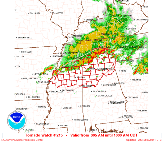
    TORNADO WATCH NUMBER 215
    NWS STORM PREDICTION CENTER NORMAN OK
    145 PM CDT TUE APR 26 2011

    THE NWS STORM PREDICTION CENTER HAS ISSUED A
    TORNADO WATCH FOR PORTIONS OF

    SOUTHERN AND CENTRAL ARKANSAS
    NORTHERN LOUISIANA
    EXTREME SOUTHEAST OKLAHOMA
    NORTHEAST AND NORTH CENTRAL TEXAS

    EFFECTIVE THIS TUESDAY AFTERNOON AND EVENING FROM 145 PM UNTIL
    1000 PM CDT.

    ...THIS IS A PARTICULARLY DANGEROUS SITUATION...

    DESTRUCTIVE TORNADOES...LARGE HAIL TO 4 INCHES IN DIAMETER...
    THUNDERSTORM WIND GUSTS TO 80 MPH...AND DANGEROUS LIGHTNING ARE
    POSSIBLE IN THESE AREAS.

    THE TORNADO WATCH AREA IS APPROXIMATELY ALONG AND 80 STATUTE
    MILES NORTH AND SOUTH OF A LINE FROM 45 MILES NORTHWEST OF WACO
    TEXAS TO 60 MILES NORTHEAST OF EL DORADO ARKANSAS. FOR A
    COMPLETE DEPICTION OF THE WATCH SEE THE ASSOCIATED WATCH OUTLINE
    UPDATE (WOUS64 KWNS WOU5).

    REMEMBER...A TORNADO WATCH MEANS CONDITIONS ARE FAVORABLE FOR
    TORNADOES AND SEVERE THUNDERSTORMS IN AND CLOSE TO THE WATCH
    AREA. PERSONS IN THESE AREAS SHOULD BE ON THE LOOKOUT FOR
    THREATENING WEATHER CONDITIONS AND LISTEN FOR LATER STATEMENTS
    AND POSSIBLE WARNINGS.

    OTHER WATCH INFORMATION...CONTINUE...WW 213...WW 214...

    DISCUSSION...SEVERE THUNDERSTORMS ARE EXPECTED TO RAPIDLY DEVELOP
    THIS AFTERNOON OVER NORTHEAST TX...SPREADING ACROSS THE WATCH AREA
    THROUGH EARLY EVENING. OTHER INTENSE STORMS WILL DEVELOP BY EARLY
    EVENING OVER NORTHEAST TX AND ALSO SPREAD EASTWARD. BOTH AREAS OF
    SEVERE STORMS WILL LIKELY INCLUDE DISCRETE SUPERCELLS CAPABLE OF
    VERY LARGE HAIL...DAMAGING WINDS...AND TORNADOES. WIND FIELDS WILL
    BE STRENGTHENING THROUGH THE EVENING...AND STORMS TRACKING NEAR THE
    EXISTING BOUNDARY FROM TX INTO AR WILL HAVE ENHANCED SHEAR AND THE
    RISK OF STRONG/LONG-LIVED TORNADOES.

    AVIATION...TORNADOES AND A FEW SEVERE THUNDERSTORMS WITH HAIL
    SURFACE AND ALOFT TO 4 INCHES. EXTREME TURBULENCE AND SURFACE
    WIND GUSTS TO 70 KNOTS. A FEW CUMULONIMBI WITH MAXIMUM TOPS TO
    600. MEAN STORM MOTION VECTOR 25035.

  14. #29
    Champ weunice has much to be proud ofweunice has much to be proud ofweunice has much to be proud ofweunice has much to be proud ofweunice has much to be proud ofweunice has much to be proud ofweunice has much to be proud ofweunice has much to be proud ofweunice has much to be proud ofweunice has much to be proud ofweunice has much to be proud of weunice's Avatar
    Join Date
    Sep 2002
    Location
    Baton Rouge
    Posts
    2,110

    Re: Severe weather 4/25-4/27

    Quote Originally Posted by splicer View Post
    I don't think anyone said that bad weather doesn't happen here, but that it has a tendency to split up here. I wedged my truck inside the garage last night in case a hail storm came, and have a couple of other nights this year. I still take precautions, but it's an interesting observation from others that they see the same weather patterns that I have, and have heard of in the past. There must be something to explain the breakup along the parish line.

    Even in your data, there were twice the number of tornadoes in Lincoln Parish than there were in Ouachita Parish in the last 60+ years.
    All I'll say is that past performance is not an indication of future returns You can have an area go 100 years with nothing and then 5 straight with unreal numbers of incidents. Such is the nature of unusual things.

    Dr. Twister I would have LOVED to have been on that team My wife on the other hand ....

  15. #30
    Champ weunice has much to be proud ofweunice has much to be proud ofweunice has much to be proud ofweunice has much to be proud ofweunice has much to be proud ofweunice has much to be proud ofweunice has much to be proud ofweunice has much to be proud ofweunice has much to be proud ofweunice has much to be proud ofweunice has much to be proud of weunice's Avatar
    Join Date
    Sep 2002
    Location
    Baton Rouge
    Posts
    2,110

    Re: Severe weather 4/25-4/27

    Note: The parallelogram is only an approximation to the watch, the actual watch is defined by the outlines of the counties contained in it.

    Tornadoes
    Probability of 2 or more tornadoes
    High (>95%)
    Probability of 1 or more strong (F2-F5) tornadoes
    High (90%)
    Wind
    Probability of 10 or more severe wind events
    High (90%)
    Probability of 1 or more wind events > 65 knots
    High (80%)
    Hail
    Probability of 10 or more severe hail events
    High (>95%)
    Probability of 1 or more hailstones > 2 inches
    High (>95%)
    [COLOR=rgb(153, 51 255)]Combined Severe Hail/Wind[/COLOR]
    Probability of 6 or more combined severe hail/wind events
    High (>95%)
    For each watch, probabilities for particular events inside the watch (listed above in each table) are determined by the issuing forecaster. The "Low" category contains probability values ranging from less than 2% to 20% (F2-F5 tornadoes), less than 5% to 20% (all other probabilities), "Moderate" from 30% to 60%, and "High" from 70% to greater than 95%. High values are bolded and lighter in color to provide awareness of an increased threat for a particular event.

+ Reply to Thread

Posting Permissions

  • You may not post new threads
  • You may not post replies
  • You may not post attachments
  • You may not edit your posts